Candace Fallon, Senior Endangered Species Conservation Biologist
If you submit data to the Firefly Atlas, you might be wondering what becomes of that information. You likely know that we are crowdsourcing data to better understand firefly distributions, seasonality, habitat associations, and more. But what does that mean in practice? And who has access to this information?
Firefly Atlas data are used by Xerces, our partners, and others to conduct research, identify and address threats, support conservation planning efforts, raise awareness, fill information gaps, and make recommendations for management. All of the data are publicly available, although specific locations may be obscured for sensitive sites. Anyone can visit the Firefly Atlas website and view basic occurrence data via the observation list or our interactive map. If you want to play around with the data, you can download the list of observations to a CSV; by using the filters prior to downloading, you can select for certain parameters, like all observations from Maryland last year, or all verified observations of a particular species. If you’re interested in a more detailed dataset that includes fields like temperature, flash description, and time of observation, just reach out to us and we can get you what you need.
LINK: Observation list
LINK: Interactive map
LINK: Reach out to us
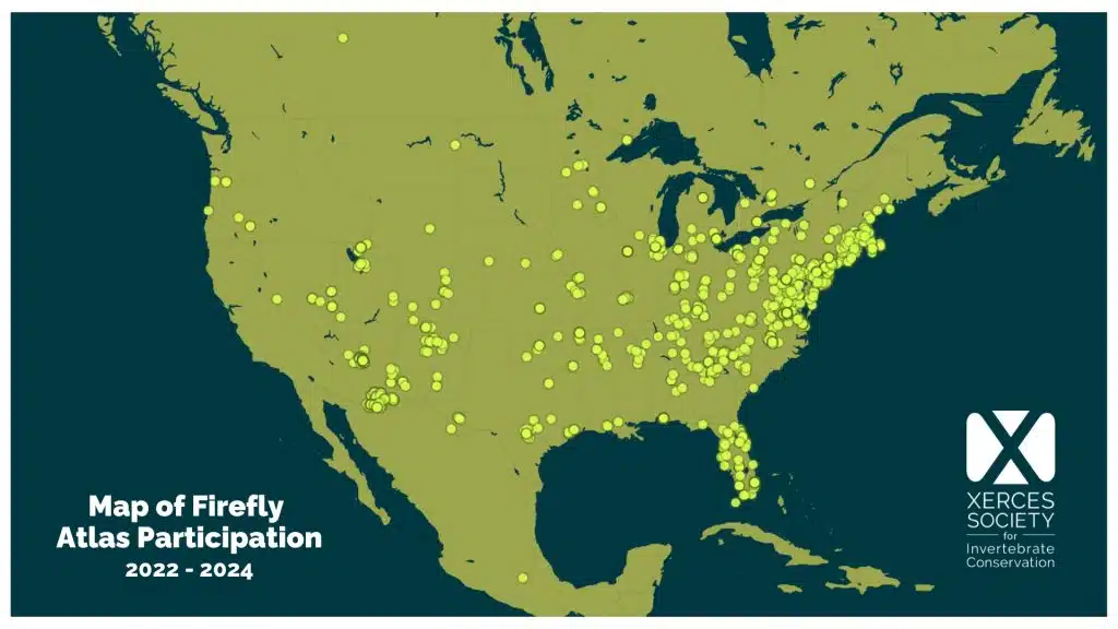
While the project is still fairly young (we just launched in 2022!), your collective efforts are already providing important data. To date, Firefly Atlas participants have submitted over 1,000 data points, encompassing 673 incidental observations and 400 targeted surveys. Of the firefly observations submitted, 123 are of one of our 13 focal species (80 of which have been verified to date). Just as impressive, all the data points thus far span 40 states and two Canadian provinces. That’s a lot of information over a large area!
LINK: Focal species
To give you a better idea of what types of projects Firefly Atlas data have been used in, we’ve pulled together some examples.
Technical guidance and conservation planning
Xerces works closely with land managers and other partners to provide science-based technical guidance in the form of fact sheets, site management plans, and best management practices. These resources provide information on what fireflies need, which species are at risk, what aspects of their life history makes them vulnerable, where they can be found, and how habitats can be better managed for their survival. All of this can help state and federal agencies, other conservation organizations, and landowners make decisions about how to protect fireflies and their habitats.
For example, we have created a series of species fact sheets that provide in-depth information about threatened firefly species, including identification, natural history, distribution, threats, key conservation and management needs, and survey guidance. These have been tailored specifically for land managers, researchers, and others interested in taking action to better understand and protect threatened fireflies and their habitats, and much of the species distribution, threat, and natural history information has been informed by Firefly Atlas survey data.
LINK: Species fact sheets
We are also using Atlas data to inform site management plans. At a state park in Georgia, we’re working with staff to develop a plan that provides recommendations for how to manage the site in a firefly-friendly way. We’re able to tailor these to specific firefly species because of Firefly Atlas surveys that have been conducted at the park, which helps us understand the habitat associations and seasonality of the resident firefly fauna.
Advocating for species protections and inclusion on state lists
We’ve also been using Firefly Atlas occurrence records to inform updates to State Wildlife Action Plans. These plans, which are updated roughly every ten years, include lists of Species of Greatest Conservation Need (SGCN) and, sometimes, Species of Greatest Information Need (SGIN). Species on these lists are eligible for federal funding to support conservation efforts such as surveys, monitoring, habitat restoration, and research. State wildlife agencies depend on species experts and conservation partners to help them update these lists and ensure imperiled species are considered for inclusion. Using Firefly Atlas data, we can develop state checklists and identify any threatened or data deficient fireflies that occur in a given state. We then make recommendations for which species should be considered as SGCN or SGIN and provide all the relevant distribution, habitat, and life history information that can help with their management and conservation.
LINK: State Wildlife Action Plans
LINK: State checklists
For some species, Endangered Species Act (ESA) protection might be the best or only way to prevent extinction. In these cases, Xerces will use all information at our disposal, including data submitted to the Firefly Atlas, to develop ESA petitions to protect vulnerable species. Both the Florida intertidal firefly and Southwest spring firefly—two of our Atlas focal species—are currently under review for listing based on petitions Xerces filed in 2023. Firefly Atlas survey efforts for these two species have ramped up as Xerces staff and other individuals try to gather more information to help inform the Species Status Assessment process.
LINK: Florida intertidal firefly
LINK: Southwest spring firefly
Research
Atlas data are also being used in several different research projects. For example, firefly observations have been used to develop species distribution models (SDMs), which help us better understand where species might occur across the landscape, and where we should focus future survey efforts. These models can also help us assess or predict things like impacts of climate change, species responses to environmental gradients, and habitat suitability—all of which can help us prioritize areas for restoration, protection, or other conservation efforts.
This SDM approach has led to some exciting discoveries. Several years ago (when the Atlas was still being developed), students at Tufts University used existing firefly occurrence datasets to create species distribution models for several threatened firefly species. After mapping out potential areas of distribution for the cypress firefly (Photuris walldoxeyi), Grace Lovett conducted some Atlas surveys in her home state of Arkansas. This led to the first documented occurrence of the species in the state. Grace is now helping to get this firefly included as a Species of Greatest Conservation Need in the state’s wildlife action plan update, and she’s also become involved with members of a local Master Naturalist group who created Arkansas’ first firefly sanctuary at Coler Mountain Bike Preserve. Another prior student, Ben Shamgocian, has continued to work with Xerces staff and Atlas volunteers to refine his model for the Southwest spring firefly (Bicellonycha wickershamorum) as we use the results to plan our survey efforts, then ground truth the map outputs and collect new data points to be fed into the model after each season.
LINK: Documented occurrence
LINK: Firefly sanctuary
The Southwest spring firefly has caught the attention of another scientist, Rachel Laura, who has made the species a focus of her PhD research. This past summer, Rachel conducted surveys to determine population abundance and assess environmental variables that influence abundance and detection. In addition to gathering species specific data using modified Firefly Atlas protocols, she also tested out novel monitoring techniques, like distance sampling, which has been used for other wildlife species like butterflies and whales. Over the course of the summer, Rachel was able to document the co-occurrence of the Southwest spring firefly and the Southwest synchronous firefly at two sites. These species were suspected to overlap at sites in southern Arizona, but had not yet been confirmed through survey data.
Survey planning and outreach
In addition to all these other uses, the data you provide also help Xerces biologists and others plan field surveys and outreach each year. We can use the observations you share to decide if we want to revisit a site to gather more information, meet with local land managers, conduct targeted outreach, or fill in gaps in a species’ range. As we sketch out our summer field season, we often check the Firefly Atlas map page in conjunction with moon phase calendars and other data layers (like habitat maps and land management layers) to plan and prioritize weekly itineraries. If there are places we know we can’t get to (which are many!) we’ll decide on some targeted outreach to engage local land managers or volunteers, provide training opportunities and other resources, and encourage everyone to get out and look for fireflies as much as they can.
LINK: Map page
We couldn’t do this without you!
Community science projects can be powerful tools for conservation, especially for small organizations or research teams with limited capacity. By contributing to the Firefly Atlas, whether through an incidental observation or a full firefly survey, you are providing important data that helps us gain a deeper understanding of fireflies, their needs, and how we can work together to ensure their future. Furthermore, you are helping us cover many more places than we would ever be able to visit on our own. With your help and enthusiasm, we’ve already learned so much more about where fireflies occur, when they are active, and what kinds of habitats they are using. We’re grateful for your participation, and look forward to what we will continue to uncover together in the years to come!
Notice: Below is a list of 12 important links included on this page.
6. State Wildlife Action Plans
12. Map page
Please note that while screen readers have made significant strides, they may still lack full support for optimal web accessibility.
Candace Fallon, Senior Endangered Species Conservation Biologist
If you submit data to the Firefly Atlas, you might be wondering what becomes of that information. You likely know that we are crowdsourcing data to better understand firefly distributions, seasonality, habitat associations, and more. But what does that mean in practice? And who has access to this information?
Firefly Atlas data are used by Xerces, our partners, and others to conduct research, identify and address threats, support conservation planning efforts, raise awareness, fill information gaps, and make recommendations for management. All of the data are publicly available, although specific locations may be obscured for sensitive sites. Anyone can visit the Firefly Atlas website and view basic occurrence data via the observation list or our interactive map. If you want to play around with the data, you can download the list of observations to a CSV; by using the filters prior to downloading, you can select for certain parameters, like all observations from Maryland last year, or all verified observations of a particular species. If you’re interested in a more detailed dataset that includes fields like temperature, flash description, and time of observation, just reach out to us and we can get you what you need.

While the project is still fairly young (we just launched in 2022!), your collective efforts are already providing important data. To date, Firefly Atlas participants have submitted over 1,000 data points, encompassing 673 incidental observations and 400 targeted surveys. Of the firefly observations submitted, 123 are of one of our 13 focal species (80 of which have been verified to date). Just as impressive, all the data points thus far span 40 states and two Canadian provinces. That’s a lot of information over a large area!
To give you a better idea of what types of projects Firefly Atlas data have been used in, we’ve pulled together some examples.
Technical guidance and conservation planning
Xerces works closely with land managers and other partners to provide science-based technical guidance in the form of fact sheets, site management plans, and best management practices. These resources provide information on what fireflies need, which species are at risk, what aspects of their life history makes them vulnerable, where they can be found, and how habitats can be better managed for their survival. All of this can help state and federal agencies, other conservation organizations, and landowners make decisions about how to protect fireflies and their habitats.
For example, we have created a series of species fact sheets that provide in-depth information about threatened firefly species, including identification, natural history, distribution, threats, key conservation and management needs, and survey guidance. These have been tailored specifically for land managers, researchers, and others interested in taking action to better understand and protect threatened fireflies and their habitats, and much of the species distribution, threat, and natural history information has been informed by Firefly Atlas survey data.
We are also using Atlas data to inform site management plans. At a state park in Georgia, we’re working with staff to develop a plan that provides recommendations for how to manage the site in a firefly-friendly way. We’re able to tailor these to specific firefly species because of Firefly Atlas surveys that have been conducted at the park, which helps us understand the habitat associations and seasonality of the resident firefly fauna.
Advocating for species protections and inclusion on state lists
We’ve also been using Firefly Atlas occurrence records to inform updates to State Wildlife Action Plans. These plans, which are updated roughly every ten years, include lists of Species of Greatest Conservation Need (SGCN) and, sometimes, Species of Greatest Information Need (SGIN). Species on these lists are eligible for federal funding to support conservation efforts such as surveys, monitoring, habitat restoration, and research. State wildlife agencies depend on species experts and conservation partners to help them update these lists and ensure imperiled species are considered for inclusion. Using Firefly Atlas data, we can develop state checklists and identify any threatened or data deficient fireflies that occur in a given state. We then make recommendations for which species should be considered as SGCN or SGIN and provide all the relevant distribution, habitat, and life history information that can help with their management and conservation.
For some species, Endangered Species Act (ESA) protection might be the best or only way to prevent extinction. In these cases, Xerces will use all information at our disposal, including data submitted to the Firefly Atlas, to develop ESA petitions to protect vulnerable species. Both the Florida intertidal firefly and Southwest spring firefly—two of our Atlas focal species—are currently under review for listing based on petitions Xerces filed in 2023. Firefly Atlas survey efforts for these two species have ramped up as Xerces staff and other individuals try to gather more information to help inform the Species Status Assessment process.


Research
Atlas data are also being used in several different research projects. For example, firefly observations have been used to develop species distribution models (SDMs), which help us better understand where species might occur across the landscape, and where we should focus future survey efforts. These models can also help us assess or predict things like impacts of climate change, species responses to environmental gradients, and habitat suitability—all of which can help us prioritize areas for restoration, protection, or other conservation efforts.
This SDM approach has led to some exciting discoveries. Several years ago (when the Atlas was still being developed), students at Tufts University used existing firefly occurrence datasets to create species distribution models for several threatened firefly species. After mapping out potential areas of distribution for the cypress firefly (Photuris walldoxeyi), Grace Lovett conducted some Atlas surveys in her home state of Arkansas. This led to the first documented occurrence of the species in the state. Grace is now helping to get this firefly included as a Species of Greatest Conservation Need in the state’s wildlife action plan update, and she’s also become involved with members of a local Master Naturalist group who created Arkansas’ first firefly sanctuary at Coler Mountain Bike Preserve. Another prior student, Ben Shamgocian, has continued to work with Xerces staff and Atlas volunteers to refine his model for the Southwest spring firefly (Bicellonycha wickershamorum) as we use the results to plan our survey efforts, then ground truth the map outputs and collect new data points to be fed into the model after each season.
The Southwest spring firefly has caught the attention of another scientist, Rachel Laura, who has made the species a focus of her PhD research. This past summer, Rachel conducted surveys to determine population abundance and assess environmental variables that influence abundance and detection. In addition to gathering species specific data using modified Firefly Atlas protocols, she also tested out novel monitoring techniques, like distance sampling, which has been used for other wildlife species like butterflies and whales. Over the course of the summer, Rachel was able to document the co-occurrence of the Southwest spring firefly and the Southwest synchronous firefly at two sites. These species were suspected to overlap at sites in southern Arizona, but had not yet been confirmed through survey data.
Survey planning and outreach
In addition to all these other uses, the data you provide also help Xerces biologists and others plan field surveys and outreach each year. We can use the observations you share to decide if we want to revisit a site to gather more information, meet with local land managers, conduct targeted outreach, or fill in gaps in a species’ range. As we sketch out our summer field season, we often check the Firefly Atlas map page in conjunction with moon phase calendars and other data layers (like habitat maps and land management layers) to plan and prioritize weekly itineraries. If there are places we know we can’t get to (which are many!) we’ll decide on some targeted outreach to engage local land managers or volunteers, provide training opportunities and other resources, and encourage everyone to get out and look for fireflies as much as they can.
We couldn’t do this without you!
Community science projects can be powerful tools for conservation, especially for small organizations or research teams with limited capacity. By contributing to the Firefly Atlas, whether through an incidental observation or a full firefly survey, you are providing important data that helps us gain a deeper understanding of fireflies, their needs, and how we can work together to ensure their future. Furthermore, you are helping us cover many more places than we would ever be able to visit on our own. With your help and enthusiasm, we’ve already learned so much more about where fireflies occur, when they are active, and what kinds of habitats they are using. We’re grateful for your participation, and look forward to what we will continue to uncover together in the years to come!